Historic Landscape Features
 George Mason married Ann Eilbeck in April of 1750, and they settled in a temporary home built by his father at the eastern tip of Mason Neck. The house occupied the top of a bluff overlooking the Potomac; the site was called "Dogue's Neck" by Mason and is currently known as Sycamore Point.
Mason was an accomplished surveyor and in 1754 he carried out an extensive survey of Mason Neck in preparation for the planning of a new house and garden. Mason might have chosen a number of fine home sites upon his vast plantations, but he selected a site he had known since childhood, a few hundred yards from the house, called Newtown, built by his grandfather in 1694.
Mason's design for Gunston's landscape is an important example of 18th-century American architecture. He placed major elements in a linear sequence leading from the entry gate on the northwest boundary, to the edge of the plateau on the southeast. Mason shaped the spaces in between with carriage roads, paths, buildings, banks of trees, and open vistas in an ingenious fashion. Unfortunately, much of Mason's original landscape plan was altered or obliterated during the 19th and 20th centuries. During the last ten years, however, researchers have worked to determine original elements of the scheme, and to recreate or restore them when possible. There have been two principal guides in this exciting process of discovery: archaeological excavation and the written "Recollections" of John Mason, Mason's son, who describes the appearance of the plantation at the time of his childhood.
After selecting the site for his house and grounds, surveying it in 1754, and consulting contemporary garden books, George Mason mapped the plan for his estate. He located major features in a linear sequence leading from the entry gate on the north boundary, to his vegetable garden on the southern edge of a broad plateau. His house was positioned at the center of the plan, and overlooked a panoramic view. Much of Mason’s original design was altered over time, but archaeologists and researchers are currently working to discover original elements of the scheme. Many of these elements are described in the “Recollections” of John Mason, son of George Mason (hereafter noted as Recollections); some of these features have been restored or replicated, and George Mason’s original landscape is slowly taking shape. A survey of his plan begins at the front gate:
The Front GateMason constructed “an uncommon high paled fence” (Recollections) from the head of a stream running to Pohick Bay to a stream head running to Belmont Bay, effectively enclosing the eastern half of the peninsula of Mason Neck. The fence marked the northwest boundary of the plantation, and the entry gate stood at the point of intersection of the old carriage road and this boundary. It is described by Kate Mason Rowland, a Mason descendant and late 19th-century writer, as “the old red gate.” The “s” curved portion of the current driveway entrance dates from the early 20th century; the old carriage road leading to the gate is now a walking trail and is located on the left of the present entrance, behind the Shiloh Baptist Church Cemetery. |
|
Original Carriage RoadThe original landfront carriage road extended axially from the mansion for approximately 800 feet, but then veered slightly to the west, very close to the course of the present drive. The original road bed was approximately twelve feet wide. On either side of the drive are huge, open fields, a consistent feature for centuries. George Mason’s prize thoroughbred, Vulcan, was pastured in the field to the left as one enters the plantation. |
|
White Gate and Fence |
|
| Near the point where the current driveway forks, was a second, inner gate in a fence that enclosed the private grounds around the mansion. The fence contained a huge rectangle of close cropped lawn extending to the landfront entrance of the house, and at its center, a spectacular allée of cherry trees. | 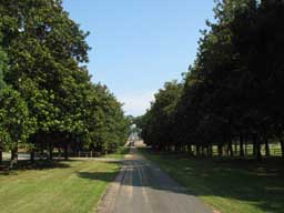 |
Black Heart Cherry Trees |
|
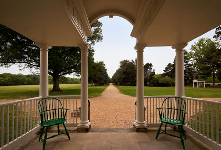
| John Mason describes his father’s double rows of Black Heart cherry trees: “On the north front . . . was an extensive lawn kept closely pastured, thro’ the midst of which led a spacious avenue girded by long, double ranges, symmetrical rows of that hardy and stately cherry tree, the common black-heart . . . commencing at about 200 feet from the house and extending thence for about 1,200 feet, the carriage way being in the center and the foot ways on either side between the two rows forming each double range of trees” (Recollections). The four rows of cherries were not planted on lines perpendicular to the mansion, but on radial lines projected from its entry door. The radiating lines of trees created a false perspective, making the trees “seem to approach as they recede” (Recollections) as the visitor progressed toward the mansion. The alignment of trees also enabled those in the mansion to enjoy a broad vista of the surrounding landscape, since the trees blocked less of the horizon than a perpendicular allée would. | 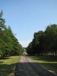 |
OrchardsBeyond the allée on the east side were Mason’s extensive orchards. Most of the location of the original orchard is now occupied by the Ann Mason Visitors Center, but in peripheral areas of the parking lot are young “Newtown Pippin” apple trees. Mason gave cuttings from “Newtown Pippins” growing at Gunston as a gift to George Washington in 1756. |
|
Logtown |
|
| On the west side of the enclosed lawn was a wood “just far enough within which, to be out of sight, was a little village called Logtown, so called because most of the houses were built of hewn pine logs. Here lived several families of the slaves serving about the mansion house. Among them were my father’s body servant, James, a mulattoe man and his family, and those of several negro carpenters.” (Recollections) | 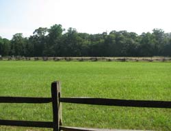 |
Mansion and Central Axis |
|
| Although the mansion house is not part of the garden, it was the focal point of the landscape plan. The cherry tree allée and other elements lead the visitor’s eye to the house, and since no mature trees grew close to it, the mansion dominated the landscape. Mason meant it to be seen standing isolated in space. He bound the house to the surrounding garden with the central axis: the carriage way leading to the mansion is twelve feet wide, the Palladian portico is also twelve feet wide, the center hall passage is the same width, as are the riverfront “gothick” portico and the gravel path leading through the center of the garden toward the south. The designs of the mansion and the garden were integrated, and the twelve foot wide axis is the spine of the composition. | 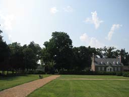 |
Regular Garden |
|
| On the south side of the mansion, George Mason leveled the “natural irregularity of the hill” (Recollections) for his garden. Four rectangles of planting beds were circumscribed by broad gravel paths, and a “spacious walk running eastwardly and westward” (Recollections) traversed the brow of the hill at the eastern edge. The precise location and dimension of these paths has been confirmed by archeological excavation, and they are surfaced with “red” gravel as they were in Mason’s time. The four beds contain almost exactly one acre, an amount of vegetable garden commonly reserved by 18th century planters for the support of the inhabitants of the main house. The outer, southern pair of beds are slightly larger than the two next tot the Mansion, engaging a forced perspective similar to that of the cherry tree allée. | 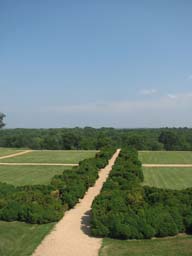 |
Boxwood Allée |
|
| Lining the central path of the four rectangles, and the edge of the garden adjacent to the house, are borders of English boxwood planted during George Mason’s lifetime. The boxwood was intended as a low hedge around planting beds; their twisted trunks may have been originally trained to grow on trellises. | 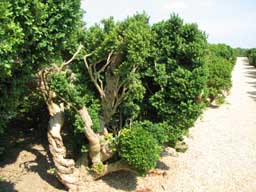 |
Viewing Mounts |
|
| Along the “spacious walkway” at the garden’s southern edge are three earthen mounds, aligned with the three north/south paths. They are confirmed as 18th century features, built as “viewing mounts” for family and guests to enjoy the expansive vista of field, woodland, the Potomac, and the Maryland shore. Apart from the obvious visual appeal, Mason needed to see out. He wanted to see his wharf for economic reasons, to see his crops go out and other goods arrive. He needed to see the river for defensive reasons, to see ships coming and going, particularly since the French and Indian War was raging precisely as he was building his house between 1755 and 1759. He would have wanted to see who was coming to visit. He needed to watch his enslaved African-American work force toiling in the fields stretching southward below his garden. The expansive vista from the mounts was critical to Mason’s welfare and security. Seen from below, the earthen mounts and the terraces on which they rest are reminiscent of a fortress, reflecting their defensive function. | 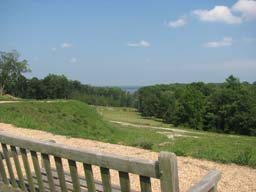 |
Terrace |
|
| Beneath the viewing mounts is a large earthen terrace. Although its dimensions were altered in the 19th century, the terrace is essentially original. It was one of a series of terraces which probably stepped down to the level of the Deer Park below. This series of terraces, often called a “falls” or “fells”, were typical features of 18th century Chesapeake Bay area gardens which were “carved out of the hills” overlooking the bay or its tributaries. Mason constructed an almost identical bank of terraces in the garden of “Lexington”, a house he built for his son, George V, just west of Gunston Hall. Chesapeake planters sometimes grew vegetables or flowers on the level surface of the terraces; more often, most of the flat and sloped areas were turfed. | 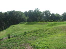 |
Deer Park |
|
| Below the terraced hill was George Mason’s fenced Deer Park, studded with trees and “stocked with native deer, domesticated.” Such deer parks were a common feature of English estates; they were largely ornamental, and often placed along an entry road. George Washington also had a fenced deer park on the low ground in front of “Mount Vernon”, and these two examples are among the few documented deer parks in 18th century America. Mason’s park is still heavily populated with deer. | 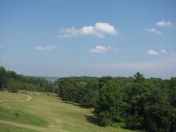 |
The Landing RoadOn the eastern side of the garden is a deep ravine. The original course of the road to Mason’s landing on the Potomac begins at the head of the ravine, due east of the medial cross path of the four rectangles. It curves toward the south, and emerges from the ravine into the deer park, then curves again to the east toward the Potomac shore. Archaeology and documentary research have determined the location where goods were loaded and unloaded next to the mansion, and the location of the wharf on the Potomac shore. |
|
Slave QuarterBeyond the paled kitchen yard were a “corn house granary, servants houses (in the 18th century called “negroe quarters”), a hay yard, and cattle pens, all of which were masqued by rows of large cherry and mulberry trees” (Recollections). None of these structures now exist, but the location of slave quarters is marked with interpretive signage. |
|
Barn and StableTo the west of the mansion, beyond the schoolhouse, was the barn and stable complex. The barn was demolished in 1949, but rough stones outline the original foundation of the structure. A stone and earthen ramp still stands adjacent to the barn site; it enabled animal and vehicular access to the second level of the barn. |
|
Burying GroundOn the edge of the high ridge to the west of the mansion, beyond the old barn site, a 20th century allée of cedar trees leads to the Burying Ground. George Mason, his first wife Anne, and many Mason descendants are buried here. The brick wall enclosing the yard was constructed in the 1920s; there are as many unmarked graves outside of the walls as there are marked graves inside of them. John Mason states that the family could not restrain George Mason from repeatedly walking to the grave of Ann after her death in 1776. |
|